
Blizzard vs. Winter Storm: Definitions, Differences, and Home Preparation

- A blizzard is not defined by how much snow falls. The National Weather Service defines a blizzard by sustained winds or frequent gusts of 35 mph or more, visibility reduced to 1/4 mile or less by falling and/or blowing snow, and those conditions lasting at least three hours.
- A winter storm is the broader category. It includes heavy snow, sleet, freezing rain, and mixed precipitation events that do not meet blizzard criteria.
- A ground blizzard can occur on a day with little or no new snowfall if wind is picking up snow already on the ground and reducing visibility to blizzard thresholds.
- Winter storm warning thresholds for snowfall accumulation are set locally by NWS offices, not by a single national standard.
Most people use the word "blizzard" to describe any severe snowstorm. The National Weather Service uses it to mean something more specific, and the distinction matters for understanding forecasts, alerts, and travel risk. A storm can dump 18 inches of snow without qualifying as a blizzard. A storm with only two inches of new snow can qualify if the wind is strong enough.
This guide explains the official definitions, how blizzards and winter storms differ in practical terms, what a ground blizzard is, and how to prepare your home and household for the power outages and hazards that severe winter weather brings.

What Is the Actual Difference Between a Blizzard and a Winter Storm?
A winter storm is the umbrella term. It describes any significant winter weather event that creates dangerous travel or hazardous conditions, whether the primary threat is heavy snow, sleet, freezing rain, or a combination of precipitation types. A blizzard is a specific type of severe weather within that category, defined not by what falls from the sky but by what happens to visibility.
The key distinction is this: winter storms are categorized primarily by what accumulates; blizzards are defined primarily by what you can see, or rather, what you cannot.
What Conditions Officially Define a Blizzard?
Per the National Weather Service, a blizzard requires three conditions to be met simultaneously and to persist for at least three hours:
Wind Speed
Sustained winds or frequent gusts of 35 miles per hour (56 km/h) or more. The wind does not have to be constant at 35 mph. Frequent gusts reaching or exceeding that threshold satisfy the criterion.
Visibility
Falling and/or blowing snow reducing visibility to 1/4 mile (about 400 meters) or less. The snow reducing visibility can be new snow falling, existing snow being lifted by wind, or both together.
Duration
The wind speed and visibility conditions described above must persist for at least three consecutive hours. A brief intense burst of blowing snow does not qualify. The conditions must be sustained.
Notably absent from the official NWS criteria: any minimum temperature requirement and any minimum snowfall amount. A blizzard can technically occur above freezing if snow is wet and blowing, and it can occur with little to no new snowfall if existing snow on the ground is being moved by wind.
What Counts as a Winter Storm?
Snow, Sleet, Freezing Rain, and Mixed Precipitation
A winter storm warning covers significant combinations of winter precipitation that create hazardous conditions for travel and public safety. The specific triggering conditions, primarily snowfall accumulation thresholds, are set by individual NWS local offices based on regional climate and typical community vulnerability.
A snowfall amount that triggers a Winter Storm Warning in North Carolina may be well below the threshold used in Minnesota, where residents and infrastructure are accustomed to heavier snow events.
The range of precipitation types covered by the winter storm category is broad. Heavy snowfall events that do not meet blizzard wind criteria are winter storms. Ice storms driven by freezing rain are winter storms. Mixed precipitation events combining snow, sleet, and freezing rain are winter storms.
Significant ice accumulation events that threaten power lines and trees are categorized separately as Ice Storm Warnings when ice accumulation reaches thresholds that pose a threat to life or property.
Why Warning Thresholds Can Vary by Location
NWS local offices calibrate their warning criteria to reflect what constitutes a significant and unusual event for their specific area. This is why checking your local NWS office's current criteria, rather than relying on a national threshold, is essential for interpreting forecast alerts accurately.
A Winter Storm Warning in Atlanta and a Winter Storm Warning in Buffalo are not equivalent events in terms of expected accumulation.
What Is a Ground Blizzard?
A ground blizzard is one of the most counterintuitive weather phenomena in winter meteorology. It can occur on a day when the sky is clear, and no snow is currently falling.
When strong winds blow across a flat snow-covered landscape, they can pick up existing snow from the surface and carry it horizontally at sufficient concentration to reduce visibility to 1/4 mile or less. If those winds reach 35 mph or more and the conditions persist for three hours, the NWS blizzard criteria are met, even with no precipitation occurring overhead.
Ground blizzards are most common across the High Plains, the northern Great Plains, and the Upper Midwest, where flat terrain provides little wind resistance and post-storm snow remains loose and dry enough to be mobilized by wind. They can occur hours or even a day after an actual snowfall event has ended, catching travelers off guard on what appears to be a clearing day.
Blizzard Warning vs. Winter Storm Warning

A Blizzard Warning is issued when the NWS expects blizzard conditions: sustained winds or frequent gusts of 35 mph or more combined with falling and/or blowing snow reducing visibility to 1/4 mile or less for at least three hours. This is among the most dangerous winter weather alerts issued. Travel under blizzard conditions is life-threatening, and NWS and state emergency management agencies routinely advise against any travel when a Blizzard Warning is in effect.
A Winter Storm Warning is issued when significant accumulations of snow, ice, sleet, or mixed precipitation are expected to create hazardous conditions. The specific accumulation thresholds vary by NWS local office. A Winter Storm Warning does not imply blizzard-level wind and visibility hazards, though it does indicate a significant weather event that warrants preparation and caution.
A Winter Storm Watch indicates that significant winter weather, including possible blizzard conditions, may develop. The NWS no longer issues Blizzard Watches as a separate alert product. A watch is a signal to begin or complete preparation activities before conditions deteriorate.
Alert Type |
Wind Criterion |
Visibility Criterion |
Duration |
Precipitation |
Blizzard Warning |
Sustained winds or gusts ≥ 35 mph |
≤ 1/4 mile |
≥ 3 hours |
Falling and/or blowing snow |
Winter Storm Warning |
No specific wind threshold |
No specific visibility threshold |
Varies |
Heavy snow, ice, sleet, or mixed; thresholds set locally |
Ground Blizzard |
Same as blizzard |
Same as blizzard |
≥ 3 hours |
No new precipitation required |
How to Prepare Your Home for a Severe Winter Storm or Blizzard

Essential Supplies and Communications
The most common consequences of blizzards and severe winter storms are extended power outages, blocked roads, and disrupted supply chains. Preparation for these outcomes looks the same regardless of whether the storm technically meets the blizzard definition.
Reliable communications are the first priority. A battery-powered or hand-crank NOAA weather radio provides official NWS alerts when internet and cell networks are disrupted. Cell networks become congested during widespread emergencies, and text messages often transmit more reliably than voice calls. Download offline maps before severe weather is forecast. FEMA and Ready.gov recommend preparing essential emergency supplies, with additional winter-storm provisions noted below:
-
Water: one gallon per person per day for at least three days
-
Non-perishable food for at least three days with a manual can opener
-
Medications: a seven-day supply as an additional winter-storm preparedness measure
-
Important documents in a waterproof container
-
First aid kit and any medical equipment that requires power
-
Flashlights, extra batteries, and a battery-powered or hand-crank radio
Heating, Carbon Monoxide, and Power-Outage Safety
In a winter power outage, maintaining safe indoor temperatures is the most immediate concern for occupied homes. Before the heating season, verify that your primary heating system is serviced. Identify an alternative heat source in advance if your primary system depends on electricity.
Never operate fuel-powered generators, charcoal grills, or outdoor cooking equipment indoors, even with windows open. Use only heating appliances specifically approved for indoor use, following their installation and ventilation requirements. Carbon monoxide is colorless, odorless, and accumulates rapidly indoors.
The Consumer Product Safety Commission and CDC both document fatalities each year from CO poisoning during power outages when people use combustion appliances indoors or run generators inside garages or near building openings. A working battery-powered CO detector on every occupied floor is essential.
Do not use a portable gasoline or propane generator inside a home, attached garage, basement, or within 20 feet of any window, door, or vent opening. This applies even with windows open.
Backup Power for Critical Loads
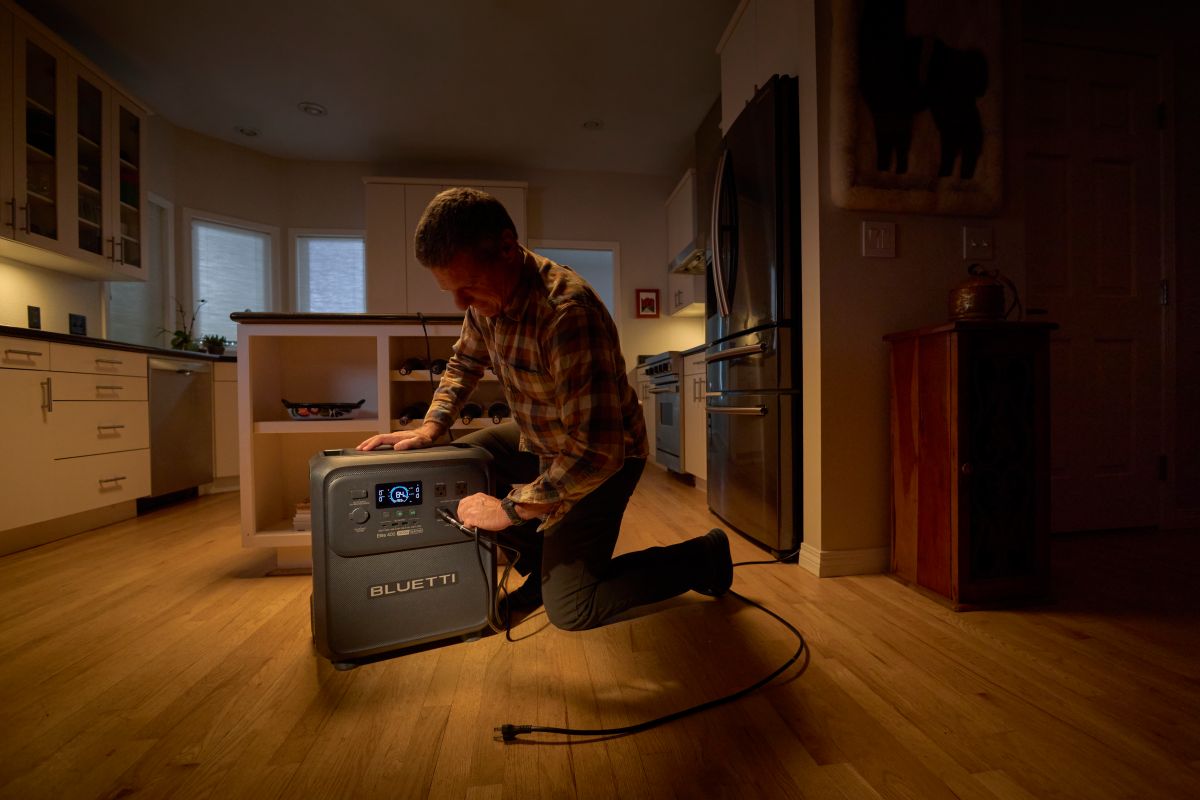
Image slot: home-battery-backup-winter-storm-power-outage.jpg Alt text: A portable home battery backup power station in a residential setting, representing a safe indoor alternative to fuel generators during winter storm power outages.
Battery-based power stations offer an indoor backup option without the combustion exhaust or carbon monoxide produced by fuel generators. They can power selected household essentials when placed and operated according to the manufacturer's ventilation, temperature, and clearance requirements.
Before any storm, identify your critical loads and estimate the daily energy they require. Common critical loads during a winter outage:
Device |
Typical Draw |
Example Daily Use |
Estimated Wh/Day |
Refrigerator (Energy Star rated) |
~150W while compressor is running |
8 hrs cumulative compressor runtime (assumed) |
~1,200 Wh |
Router and modem |
~20W |
Continuous (24 hrs) |
~480 Wh |
LED lighting (4 fixtures) |
~40W |
8 hrs |
~320 Wh |
Phone charging (2 devices) |
~30W |
2 hrs |
~60 Wh |
CPAP (without humidifier) |
~30 to 60W |
8 hrs |
~240 to 480 Wh |
Example total |
~2,300 to 2,540 Wh/day |
These are illustrative examples using typical values. Replace with nameplate or manual data for your actual devices. Actual runtime depends on device wattage, battery condition, ambient temperature, and usage pattern. For cycling appliances such as refrigerators, use measured daily energy consumption or account for compressor runtime rather than multiplying running wattage by 24 hours. The estimated daily total represents energy used by the listed devices before accounting for power-station conversion losses.
For shorter outages covering essential electronics, communications, and device charging, the BLUETTI Elite 200 V2 (2,073.6Wh, 2,600W continuous) can support a day of selected low-power loads, depending on total energy use and conversion losses. It cannot cover the full example daily load above on a single charge.


BLUETTI Elite 200 V2 Portable Power Station | 2,600W 2,073.6Wh
- 2600W | 2073.6Wh | LiFePO₄
- 15ms UPS Response Time
- 6,000+ Life Cycles to 80% Capacity
- MPPT Controller, BMS, and More
- Ideal for Home Backup and Outdoor Adventures
For households where a refrigerator is a priority load, the BLUETTI FridgePower is a dedicated refrigerator backup unit with 2,016Wh of capacity, 1,800W continuous output, and a 10ms UPS switchover designed to help maintain refrigerator operation during a grid outage. It is expandable to 8,064Wh with up to three BC200 expansion batteries for multi-day coverage.


FridgePower
- 75mm Ultra-Slim Backup Design
- 1,800W AC Output / 3,600W Peak Power
- 10ms UPS for Seamless Backup
- Expandable Capacity up to 8kWh
- Ultra-Low 4W Standby Power Consumption
For higher-capacity whole-household essential-load backup, the BLUETTI Apex 300 (2,764.8Wh, 3,840W, 0ms/20ms UPS modes) and the BLUETTI Elite 400 (3,840Wh, 2,600W, built-in wheels) offer larger storage for extended outages covering multiple loads simultaneously. Verify current specifications and compatibility on the respective product pages before purchasing.


Apex 300 Versatile Power Station | 3,840W, 2,764.8Wh
- Smartest 120V/240V Portable Power
- 3,840W | 2,764.8Wh | LiFePO₄
- 0ms UPS Response Time
- 6,000+ Life Cycles to 80% Capacity
- Dual Voltage Output & Expandable Storage
- Ideal for Smart Home Energy Management


BLUETTI Elite 400 Portable Power Station | 3,840Wh, 2,600W
- Perfectly Sized Solar Generator: 3,840 Wh capacity, just right for home backup and outdoor adventures.
- Wheels and handles for easy transport
- High Output: 2,600 W rated, 3,900 W lifting power
- Ultra-low 3 W standby draw extends runtime
- 15 ms UPS switchover during outages
Explore the full home battery backup range to find the configuration that matches your household's critical loads and expected outage duration.
Conclusion
The line between a winter storm and a blizzard is drawn by the National Weather Service using three specific criteria: wind speed at or above 35 mph, visibility at or below 1/4 mile, and those conditions persisting for at least three hours.
Snowfall accumulation plays no role in this classification. A storm can produce heavy snow without meeting blizzard criteria, and a ground blizzard can occur on a cloudless day with no new snowfall at all.
For home preparation, the classification matters less than the outcome: power outages, blocked roads, and disrupted heating. The most effective preparation happens before the forecast arrives, not during a warning.
Frequently Asked Questions
Yes. A ground blizzard forms when wind moves snow already on the ground rather than snowfall from overhead. If that wind reaches 35 mph or more and reduces visibility to 1/4 mile or less for at least three hours, the NWS criteria for a blizzard are met regardless of whether precipitation is falling. Ground blizzards are most common on open, flat terrain like the High Plains where loose, dry snow is available to be mobilized hours or days after an actual snowfall event.

Shop Products for This Article


You May Also Like